The Idaho Falls City Canal
The Idaho Falls City Canal
A Canal Built to Generate Electricty
By James C. Bennett
May 4, 2006
As the area history of canals go, the Idaho Falls City Canal was unusual in that it wasn't built for irrigation but for the generation of electrical power. Thomas Edison had invented the electric light bulb a few years earlier and the public was anxious to find an alternative to messy, labor intensive kerosene lighting that was being used in area homes and for street lighting.
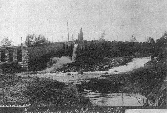
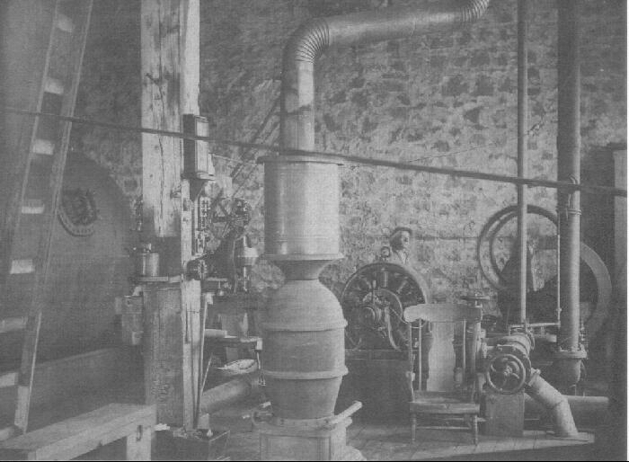
Since no private company had yet brought electricity to the area, Mayor Joseph A. Clark and his council decided that the city should provide a source of electricity to power the “new electric lighting” that the people so wanted. The city plan was to place a power plant at the base of the hill at 10th Street and Boulevard in Idaho Falls and to power its water wheel with water to be brought to it by a canal from the river several miles north of town. In 1900 a bond election was passed and the plant was built by D. Swineheart for $4,650
Perham Brothers Contractors completed a canal to bring water from a rock crib dam located just below the present day upper power plant down to the Boulevard power plant. By 1901 the plant was in operation. The discharged water from the plant was dumped into Crow Creek and returned to the river through the lava rock arch under the railroad track near 16th street.
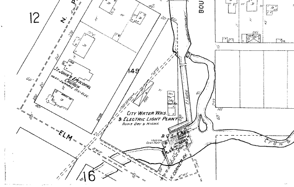
The route of the canal from the crib dam basically followed the east bank of the Snake River to the Butte railroad tracks, then veered southeast to go under the overpass toward Anderson Street near the grade school. Here it entered a rather large lake covering the north ends of Bingham, Bear, and Bannock Streets. Water was stored in the lake to be released as needed by the power house. From the outlet of the lake it veered southeast toward North Lee which it followed to about College Street where it passed under the main line of the Union Pacific Railroad. It pretty much followed the east side of the tracks to Boulevard and down Boulevard to the 10th Street power house and its 125 horsepower generator. About seventy-five percent of the power plant building was located in the street right-of-way of either Boulevard or Corner Avenue, with the remaining twenty five percent located where Liberty Park is today on the west side of Boulevard near the intersection of 10th Street.
The power plant was built at the bottom of the gulley that had been cut by Crow Creek. It was perhaps 15 feet below todays street level . When the plant was dismantled and removed, fill dirt had to be hauled in to bring it up to street level for the Liberty Park that is there today.
Bridges over the canal were placed at North Eastern Avenue, 6th Street, 8th Street and 9th Street, so that residents could reach the area east of Boulevard. The late Orville Buck, local undertaker, lived next to the canal on 5th street and recalled to me that as a young lad he was admonished to keep away from the canal but when the water was turned down, he was allowed to wade in the water with supervision and even try his hand at fishing.
Electricity was used for lighting only. Customers were charged 50 cents for the first two lights and 40 cents for the next two lights and 30 cents for each additional light.
A new power plant was constructed on the river near where the water tower stands today and went on line in 1912. The old plant was dismantled and torn down in 1914 and 1915. The Boulevard section of the canal was covered over in about 1914 and Boulevard became a street rather than a canal.
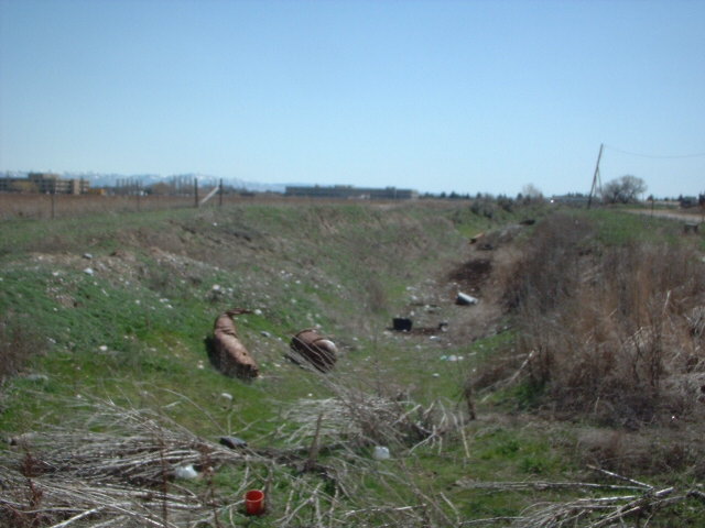
Even in 2006, there are still traces of the old canal to be found 92 years after it was abandoned. Just west of the Anderson Street grade school there is a large vacant area where some of the old canal bed can be found. Just south of where Iona Road dead ends at the river, several sections are remaining. In Idaho Falls on the east side of Boulevard at 5th Street there is still a sunken area where dirt was taken to construct the canal.

Exterior of the City Canal Power Plant.

Inside of the City Canal Power Plant.

Location of Power Plant

Plant Location From a 1911 Sanborn Insurance Map

Old Canal Bed South of Iona Road Near the River
Here are some documents of interest:
Idaho falls - City of Destiny
VIDEO: Downtown Memories of Idaho Falls
VIDEO: History of Transportation in Idaho
VIDEO: Water to Dry Ground presentation
about our canal system
Centennial Celebration Program [PDF]
The City Canal
The York School
County Census info: 1870-2006
Useful Resource Books
Read about the town of Eagle Rock, Tautphaus Park, and Charles Tautphaus - by E. P. Henry
A History of Tautphaus Park, the Tautphaus Family and those that followed - by Jim Bennett
Historic Bonneville Hotel - by Jim Bennett
Early Eagle Rock and Idaho Falls Maps
A History of Sportsman Park by Jim Bennett
Rose Hill Cemetery items of interest
On the City Lifestyle, Kuna Website: Lost Elegance